Topography - Earthworks 2.0.0
Paid Version
Publisher Description
Topography - Earthworks - Earthworks and Road Layout calculations in the palm of your hand!
Complete topographic leveling tool for both field work in road construction.
Road-building tool: complete set of tools for leveling in route, comprising:
- Manager mile markers: from a txt file format, which previously we added a list of mile markers, we can get the height of flush kilometer we need, even if present in a section with vertical agreement . And besides, at the time of calculating the level, will also calculate the left and right camber (in the sense of lower kilometer to kilometer higher), which correspond to the kilometer calculated. Obviously, these data are stored, and we use them in reframing tab order to work with them.
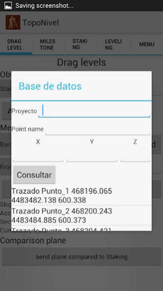
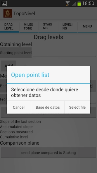
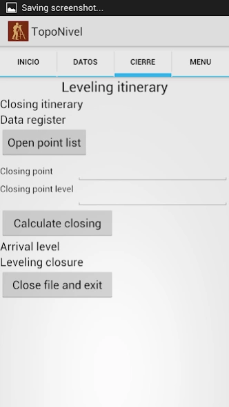
- Drag and closing levels: using leveled to reach the work area. In the case of drag, to reach the area, calculate our comparison plane and send it to the stakeout tab. To close, we will have all the necessary functions to start the journey back, and get to our starting point, calculating the closure of leveling.
- Staking: starting from our grade level, camber, and comparison plane obtained in the tabs above, we can calculate quickly and easily the elevation of any point we need in our road layout. It cant be changed at any time, and update the data when necessary.
Leveling routes registration and precise leveling
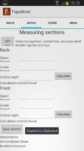
- Normal Leveling: leveled reading log middle, and intermediate points function to register (name and its corresponding point elevation) that are of interest to our work.
- Precise leveling: read the three threads, and comparison of the central wire read, with the central wire calculated by the program.
- All the level and intermediate points collected will be stored in a txt file, to work with him later in cabinet.
Points leveling tool: ideal for civil works. From a known height, we can get a comparison plane, and calculate leveling staking any point we need, without having to calculators, or accessories of any kind.
About Topography - Earthworks
Topography - Earthworks is a paid app for Android published in the System Maintenance list of apps, part of System Utilities.
The company that develops Topography - Earthworks is GeoSoftware. The latest version released by its developer is 2.0.0. This app was rated by 1 users of our site and has an average rating of 3.0.
To install Topography - Earthworks on your Android device, just click the green Continue To App button above to start the installation process. The app is listed on our website since 2017-09-10 and was downloaded 15 times. We have already checked if the download link is safe, however for your own protection we recommend that you scan the downloaded app with your antivirus. Your antivirus may detect the Topography - Earthworks as malware as malware if the download link to com.topografia.nivelaciones is broken.
How to install Topography - Earthworks on your Android device:
- Click on the Continue To App button on our website. This will redirect you to Google Play.
- Once the Topography - Earthworks is shown in the Google Play listing of your Android device, you can start its download and installation. Tap on the Install button located below the search bar and to the right of the app icon.
- A pop-up window with the permissions required by Topography - Earthworks will be shown. Click on Accept to continue the process.
- Topography - Earthworks will be downloaded onto your device, displaying a progress. Once the download completes, the installation will start and you'll get a notification after the installation is finished.
